

Australian trekkers, climbers, backcountry skiers and mountaineers lucky enough to take their passion to the United States usually set their sights on the Wild West. Daydreams have them picking their way up the angular peaks of the Rockies or carving lines down the muscular slopes of the Cascades. Denali, Rainier, Longs Peak; these are the summits that live in the imaginations of adventurers when they think of the US.
As a result, America’s White Mountains usually get overlooked. Located in state of New Hampshire, at the far northern end of the Appalachian Chain, the Whites aren’t as sexy as their Western counterparts. If Australians know anything about New Hampshire at all, it’s probably because they were forced to read Robert Frost in high school—which isn’t necessarily a bad place to start; the woods here are ‘lovely, dark and deep’.
Above the treeline though, the Whites, because of their steep terrain, combined with climate factors of the northern latitudes, relief, and proximity to the ocean, produce conditions that are comparable to those in the planet’s greatest ranges. Formed by continental collision, shaped by glaciers, and affected by the region’s famously extreme weather, the terrain is uniquely suited to outdoor recreation.
New Hampshire has a long but understated history of skiing, climbing and trekking, and it’s home to a dedicated breed of outdoor people that have a deep connection to the mountains. Adventures in the White Mountains are inextricably linked to the regional climate. Storms are followed, sunny days are treated like public holidays, and snow and ice conditions are monitored obsessively throughout the winter season. Beyond the fleeting excitement that weather can produce, there is also a deeper, almost ineffable tie to the character of the landscape itself. People that live and play in the White Mountains have adapted to engage with the particular nuances of their natural environment.
The distinctive styles of backcountry skiing, trekking, and climbing in the region have all been informed by the geomorphic architecture where these rituals play out. In a sense, the mountains are a place of worship and these activities are spiritual practice, the tenants of which are informed by the movement of glaciers and by the quiet workings of groundwater and frost. It’s no wonder then that the people of New Hampshire have adopted as their moniker a name that pays reverence to the very material from which these cathedrals are built. They call themselves “Granite Staters”.

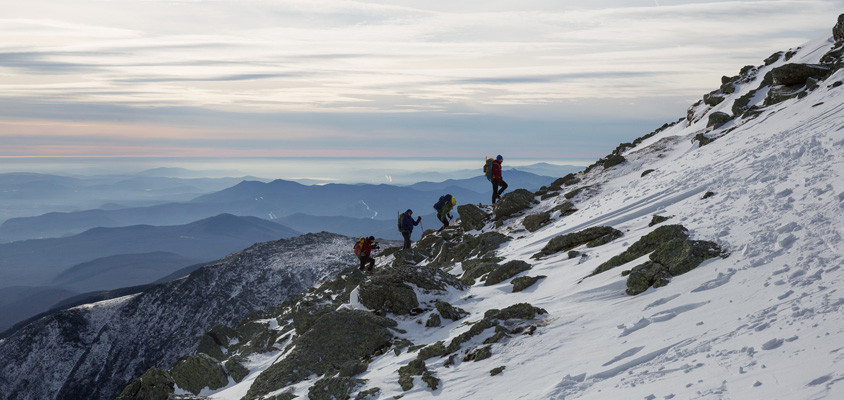
Following the cairns to the summit.
Anatomy of an Ancient Geological System
If we think of the Appalachian Chain as a snake slithering up the eastern seaboard of the United States, the Whites would be the head. At 3,200 kilometers long, the Appalachians extend north-east from the subtropical forests of the Deep South to the border with Canada, a wall of mountains separating the Atlantic coastal plains from the vast interior lowlands. Formed 460 million years ago they are among the oldest mountains on earth, the seam where an ancient ocean once closed. Like a colossal, prehistoric scar, the Appalachian Chain is evidence that at one time all the world’s continents came together into a single landmass called Pangaea.
Unimaginably slow and violent, the collision that these mountains were born out of fused the eastern margin of ancient North America with the coasts of Africa and Europe. Entire chains of volcanic islands and even small continents were swept up in the process. Viewed from space, the impact would have resembled a cartoon car wreck: the earth was crumpled and pushed skyward into jagged mountains, corrugating the bedrock like sheet metal. By the time the suturing together of Pangaea was complete, the Appalachians had risen to become the planet’s grandest mountain range, a belt of peaks that, at one time, was as tall as the Alps.
There are 48 peaks over 1,200 meters tall—known as the “four-thousand footers”—in New Hampshire. Compared to other regions of the Appalachian Chain, the Whites have an especially precipitous, rugged topography. Climate plays a role in this distinction. While the Appalachian Blue Ridge Mountains—located in the Carolinas—are home to the highest summit in the eastern United States, the climate is nevertheless too warm to support an alpine zone. Southern ranges lack the treeline found in the Whites. The highest parts of the Blue Ridge are generally coated in dense spruce-fir stands.
There are elemental differences as well. While most southern Appalachian mountains are built out of sedimentary rock, the Whites are composed of igneous and metamorphic material. Nearly all the rocks you find in the Whites are related to the assembly of Pangaea and the tectonic uplift, or to the later period of Pangaea’s breakup when North America drifted free, some 240 million years ago. In addition to the state’s namesake granite, the mountains of New Hampshire are layered with metamorphic schists, quartzites, and gneisses. These rocks, once sediments on the floor of an ocean, were deeply buried and heated during mountain formation until they became malleable like warm dough, and were folded upward. As you are hiking along the region’s trails, you can see the shapes of these folds in the sides of cliffs, some the size of mountains themselves, frozen in time.
But the processes that made this landscape truly distinctive occurred in the (relatively) more recent geological past. According to Brian Fowler, a geologist at the Mount Washington Weather Observatory, “the White Mountain landscape was significantly changed by Pleistocene glaciers. The most recent one, called the Laurentide Ice Sheet, attained a thickness of over a mile. The ice sheets had enormous weight and eroded the bedrock as they flowed across the region.” Most of the iconic features of the White Mountains are the work of glaciers. Small glaciers form at high elevations on the flanks of mountains around the world. Large glaciers, known as continental ice sheets, develop around the polar regions and can cover vast areas of the Earth’s surface. These immense tracts of ice flow like frozen rivers under the force of their own weight.
The advance of the last “ice age” came in waves, between 2.6 million and 11,700 years ago: the Pleistocene epoch. As the continental ice sheet advanced and retreated, it would follow the path of least resistance, initially grinding its way though the mountains via pre-existing valleys. These avenues of first passage are preserved today as the spectacular steep-sided “notches” for which the White Mountain region is famous.
At the last glacial maximum (roughly 25,000 years ago) Fowler says that, “the Laurentide Ice sheet eventually covered the entire region including the summits of high mountains.” Like geologic bulldozers, glaciers pluck out and transport large chunks of rock, scouring and grinding the bedrock beneath the ice in the process. Tangible evidence of their monumental earthmoving effects can still be found. Conspicuous boulders of distinctive and localised rock types are often found near the summits of mountains were they don’t belong, having been carried southward as the glacier advanced. Ice sheets also scoured away the decomposed rock and loose sediment that had formed on top of mountains during millions of years of weathering and stream activity prior to the ice age. The exposed rock and lack of suitable soil, combined with the region’s extreme winter climate, accounts for why so many White summits rise above tree line…
…The story continues in Wild issue 147. Subscribe today.