

The entire Three Capes Track has won numerous local and international awards, including both Tasmania’s and Australia’s Best New Tourism Business for 2016.
In spite of the reservations some of my fellow hikers may have in the opening up wilderness areas to commercial operators, the Three Capes Track is likely to become one of Australia’s great outdoor multi-day hikes.
Getting there
Bookings for the hike must be completed in advance via the Three Capes Track website of via one of the several operators who provide a range of additional services as part of the trip. Bookings can quickly fill and you should plan to book several months in advance, especially during the warmer months.
Most hikers will start and finish the hike at the nearby Port Arthur Historic Site, well worth a full day of exploration on its own.
Port Arthur is approximately 100km south of Hobart or 90-minutes drive. Other than self-driving, several coach services operate between the two locations:
Pennicott Wilderness Journeys: pennicottjourneys.com.au
Gray Line: grayline.com.au
Tassielink Transit: tassielink.com.au
In addition, private taxis and charter operators can be organised through the Tasmanian Visitor Information centre at Port Arthur (03 6251 2371 or tvin@portarthur.org.au)
Description of Hike
The following Track Notes are based on the official Three Capes Track hiking route.
Note: You can still complete most of the hike without paying the $495 fee. This alternative route starts and ends at Fortescue Bay, with only the short section between Denman’s Cove and Tornado Ridge missing. Camping is only permissible at Wughalee Falls. This route requires a two-day Parks Pass ($24).
Day 1: Port Arthur to Surveyors
1¼ hour boat cruise; 4 km, 1½-2 hour walk
The first stage of the hike requires a boat ferry from Port Arthur to Denmans Cove, just across the bay. While the direct distance is quite short and can be completed direct, many hikers opt for a longer ride in which the boat ferry hugs the coastline, with views to the white sands of Crescent Bay, and the headland at Arthurs Peak. Brief glimpses of Tasman Island and Cape Pillar in the distance whet the appetite of what is to come.
After a little over an hour, you’ll disembark on the sandy beach of Denmans Cove in the Tasman National Park. It’s not far to your first night’s rest so if you’re in the mood, enjoy a chilly dip at Denmans.
After departing Denmans, your walk begins. For today and for part of tomorrow you’ll head due south through coastal heathland and eucalypt woodland.
The accommodation for the first night, Surveyors is located 120m above sea level at the edge of a broad, buttongrass plain, flanked by low eucalypt scrub. There are views south-west to Cape Raoul and the setting sun.
Day 2: Surveyors to Munro
11km, 4-4½ hours
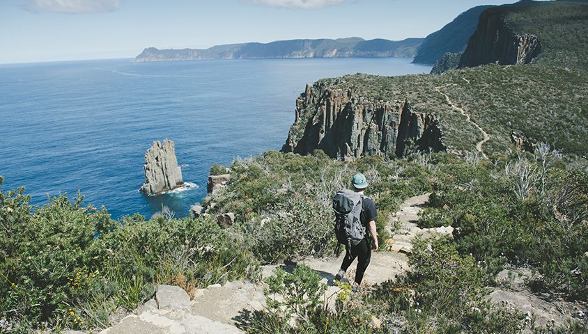
Enjoy the myriad of colours and patterns as you move in and out of the changing eucalypt forests and stroll across open moorlands. You’ll get occasional water views to the west too. After a gentle climb to Arthurs Peak you’ll be rewarded with a view over Crescent Bay and Mount Brown to the distant towering spires of Cape Raoul.
Turning east, you’ll meander along the cliff-top through the shadows of the forest. Soon you’ll break out of the treeline onto the windswept low coastal heath of Ellarwey Valley. Then it’s back into the shelter of the forest this time, a beautiful tall eucalypt stringybark forest filled with birdlife. Wallabies are often seen here too.
At the track junction, you’ll turn south and walk through more stunning forest and colourful heathlands.
Your second night’s destination, Munro, is nestled amongst tall eucalypt forest, perched 242 metres above the sea cliffs of Munro Bight. Your view this evening is of the cliffs of Munro Bight, all the way to Cape Hauy.
Day 3: Munro to Retakunna via The Blade
17km, 5 hours
This is the day of dizzying heights. You’ll be heading out and back to The Blade, near Cape Pillar, so leave your backpack at Munro and just carry a daypack with essentials.
There are several spots to relax for lunch, including at Seal Spa, sheltered beneath the sheoaks, viewing across to Tasman Island and up to The Blade. Enjoy the vast views and fresh air from one of Australia’s most southerly points.
Heading back via Munro, you’ll collect your backpack and head north to your final night’s accommodation at Retakunna set on the edge of low eucalypt scrub and moorland, at the foot of Mount Fortescue. Your view this evening is of Cape Pillar and the forested bulk of Mount Fortescue tomorrow morning’s climb.
Day 4: Retakunna to Port Arthur via Cape Hauy and Fortescue Bay
14km, 6-7 hours
Today you get to do it all. Climb a mountain. Wander through a lush rainforest. Follow the thin rind of a coastal cliff. Stand on the edge of yet another cape. Meander through fragrant heathlands. And end your experience at a most perfect beach.
But first things first: up and over Mount Fortescue. TAS Parks have crafted a gently contoured climb, so the walking is not too difficult.
The gentle downhill run to the Cape Hauy track junction meanders first through ancient rainforest, with enormous tree ferns and sky-high eucalypts, before breaking out onto eucalypt woodlands, with occasional cliff-top lookouts across the Tasman Sea.
Another short detour to Cape Hauy is best completed without your pack. Once back at the junction, you’re almost at the end. Savour the gentle downhill run to Fortescue Bay through more fragrant coastal heathland.
At Fortescue, if you’ve time before boarding the bus, reward yourself with boots off and sand between your toes or indulge in a swim in the cleanest water in the world.
Summary of Hike
Day 1: Port Arthur to Surveyors
1¼ hour boat cruise; 4 km, 1½-2 hour walk
Day 2: Surveyors to Munro
11 km, 4-4 ½ hours
Day 3: Munro to Retankunna (via The Blade
17 km, 5 hours
Day 4: Retakunna to Port Arthur (via Cape Huay & Fortescue Bay)
14 km, 6-7 hours