

A CLOSE CALL ON WOLFANG PEAK
A Wild reader recounts her harrowing experience on what seemed a short and simple outing. And there are lessons we can all learn from the event.
Words: Julia Thorn
On the morning of Monday, 17 August 2020, I set off from Emerald in Queensland’s Central Highlands to drive three hours to Nebo, 80km on my side of Mackay. I had been in Emerald after finishing the 90km Carnarvon Gorge Great Walk two days earlier and was heading to Nebo to begin the 60km Mackay Highlands Great Walk in Eungella National Park.
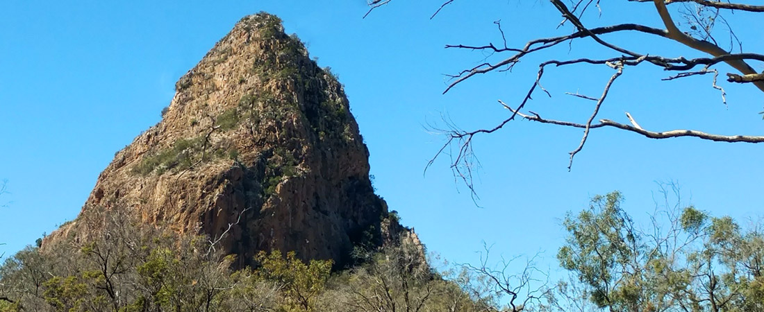
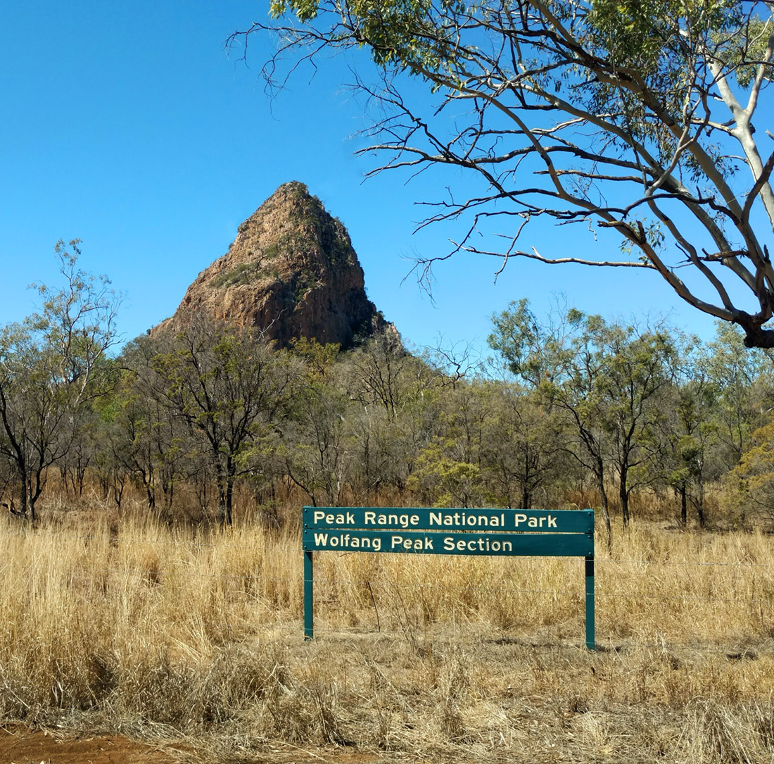
It’s 300km from Emerald to Nebo. Much of the route is on the Peak Downs Highway, in the heart of coal mining country, and settlements on the way are few. But roughly halfway into the drive, near the town of Clermont, sits 572m Wolfang Peak, a sharply protruding volcanic plug that juts 250m above the surrounding scrubby plains. I’d read about the mountain, which sits in the Peak Range National Park, in a tourist brochure; there was an out-and-back walk to its summit which supposedly took one hour each way. But the brochure was light on details, so I’d also read a couple of blogs to see what they said. And what they said was that serious information was hard to come by. Nonetheless, climbing Wolfang seemed a fun way to break up a long drive.
After getting coffee and a donut in Clermont, I drove another 30 minutes, turned onto a sandy road, and then parked. And then I performed a sequence of actions that would soon prove crucial to survival: I had a big drink of water; I put on a long sleeve shirt and sun block for protection (something I don’t always do on short hikes); and I grabbed my fully-charged phone (that’s something else I don’t usually do—charge it while driving). And then I set off. It was 12:14PM.
But not every action I took before setting off proved fortunate. Considering the walk too short for it to be necessary, I left my PLB behind. I should have known better; on another occasion, I had not taken the PLB on a short hike and had encountered several snakes—I clearly hadn’t learnt my lesson. And the PLB wasn’t my only critical error—I hadn’t told anyone I was heading up the mountain.
“Do I face into the rock? Or face out? I couldn’t decide. What was clear was, however, was that a mistake here would be serious. And that’s when I slipped and fell.”
There was one other error; it turned out I’d parked at the wrong spot and had given myself an extra two kilometres of walking. But never mind. I walked down the dirt access road, and when I thought I was at the nearest point the road would get to the peak, I climbed the wire fence and, as instructed in the blogs, crossed the woodland paddock towards the base. I have a vague recollection of wondering if this was the correct starting point or if I should have started about half a kilometre earlier. Still, my start point seemed to match the blog posts, and I wasn’t worried about climbing the fence, because the blogs were quite old and the national parks folks could well have put up a fence recently. And there were faint trails in the paddock which could have been made by previous walkers. Or animals. Animals now seem the more likely cause, but it’s worth stressing that this early on I didn’t have any feeling that it could be remotely out of the ordinary to do this walk.
I reached the base and soon saw the pink guidance tape on trees mentioned in the blogs. All good. I climbed easily on the dirt and then over rocks. There were a few patches of bush and trees, but higher up it was all rock, some of it smooth and the rest mainly large rectangular blocks. By now the route was marked sporadically with red or white paint on the rocks or cliff faces. The white markers were partially rubbed off and looked older. It wasn’t easy peasy, but I’ve done far more challenging climbs without a second thought.
After a few scrambles, again nothing heart stopping, I passed a couple of cairns and reached the top. I admired the 360-degree views of scrub, stunted trees, other peaks, a few farms, all below the wonderful blue sky. In one direction the highway formed a straight line across my field of vision. It was a gorgeous late winter day, completely still. But I didn’t linger because, I have to admit, I was a touch nervous about the descent.
I came down the higher steep part without difficulty, but then came to a confusing marker. I didn’t know what to do. I remembered the marker from my ascent and was convinced I had approached it from below, so I decided to continue descending. In hindsight, I don’t think I tried hard enough to understand the ambiguous painted marker; it’s troubled me ever since, because I can’t see why I made the decision to go the way I did. I don’t think I’ve ever been hiking somewhere like this where a detour off the curriculum could have such devastating consequences.
And then I reached a tricky place on the rocky mountainside, where I had to repeatedly manoeuvre my feet to get into a good position for the next part, a short but almost vertical descent. Do I face into the rock? Or face out? I couldn’t decide. I momentarily considered taking off my running vest (backpack) as I feared the bulging pockets would push me away from the cliff face; thank goodness I didn’t do that. What was clear was, however, was that a mistake here would be serious.
And that’s when I slipped and fell.
A lot went through my head as I tumbled. But my mind has rendered the full details of the fall somewhat hazy, no doubt as part of my coping mechanism. For example, I thought at the time I had banged my head as I fell; now I’m not sure. I’m fairly certain, though, that I tried to grab a bush as I passed it.
I still, even now, don’t know how far I fell. I do know, however, that I’d landed past the point I had just been looking down on. When I finally came to a stop, my first thought was simply this: ‘I am alive.’ Then I looked at my right ankle. I expected to see a bone sticking out of it; it hurt a lot. But no bone was showing. My left leg, however, was bleeding. It had a dramatic gash from knee to ankle, and there were several grazes. Surprisingly, however, I had no pain on that leg.
My body seemingly okay after my brief examination, I continued back to my car. Walking wasn’t pleasant, but it was possible, and I had to do it, so I did it. I looked at the trail I’d created with the GPS on my watch on my outward route to see how far I currently was from that line; it didn’t seem far. I decided to try to continue in that direction. (That’s what I always do when I’ve gone off course and usually this delivers me back to the correct trail.)
After walking across a small scree slope and scrambling along the edge of another cliff (which I really shouldn’t have done in my injured state) I reached, after maybe only 30m, a metre wide ledge; I could see no possible way forward. I could not get back to my outward GPS trail. Ahead horizontally was a big gap in the rockface and below was a seriously big drop, pretty much down to the paddock. Almost instantly I became terribly scared. I saw I was in a life-threatening predicament. On this cliff edge, going back would have been dangerous. And continuing onward was impossible.
I turned on my phone. Happiness washed over me; I had a strong signal. I called my husband in Melbourne to alert him. And then I called 000. It was 2:22PM.
The police answered immediately. They and had some trouble working out what part of Queensland I was in, but once they located me the rescue was under way. I felt overwhelming relief. From now on my fate was in the hands of experts and I knew I was completely safe where I was on this ledge. The sun blazed down on me, but I had my sunblock.
The paramedics, SES and police were soon in constant contact by phone. A paramedic asked several routine questions, including my COVID status. She asked my age and I said I was 63, which I sensed surprised her; this surprised me too because I am only 62, so I guess my mental state wasn’t great at that moment.
After about 30 minutes I saw the first signs of rescue activity: a police car, an ambulance and one other vehicle. They entered the dirt access road, but to my dismay they drove past the point where they’d be nearest to me, and almost out of my sight. Then they phoned to say they couldn’t see me. At the time, I was convinced I was easily visible from the highway. It was only 400m away, but I was halfway up a pink-tinged mountain wearing pink, and 400m is a big distance when it comes to spotting a speck on a mountainside. Clearly this notion was ridiculous.
Soon I saw a group of people walk from the vehicles towards the base of the mountain and then continue towards the backside until I could no longer see them. This was a feature of my entire rescue: I would carefully explain how I was facing the highway; the rescuers, however, would act as though I was on the backside of the peak. In hindsight, there is a reason for this: that’s where the walking trail is.
I now have to question whether I was ever on the correct trail. No trail is shown on the map automatically downloaded to my GPS watch or on the map I downloaded to my phone so I will never know for sure. But I have now concluded that had I not been injured, my best option would have been to return to the top and try to descend again staying with the markers.
At 3PM, the helicopter pilot from RACQ Central Queensland Rescue phoned; his chopper was an hour away. That felt good to hear. I could easily sit there for an hour, although even moving slightly to prevent going numb from sitting in the same position for too long scared me. There was a drop to the foot of the mountain right in front of me.
In my running backpack I had two muesli bars, half a litre of water, sunblock, phone, a purse and that’s all. I had lost my sunnies in the fall, but I’d retrieved my pink cap. Sitting in the full sun, with no shade whatsoever, I was becoming quite dehydrated. I hadn’t eaten or drunk since Clermont apart from the water at midday at the car. Or had a wee. The paramedics told me not to eat or drink, which seemed odd on a hot day, but I did as I was told.
I gazed mindlessly at the other peaks dotted around the plains and wondered what was growing in one rather distinctively bright green field across the highway. Occasionally, a vehicle would cross my view along the highway.
+++++++++
I heard the chopper way before I could see it. It came so close I was sure it must have seen me, but then it went away; the pilot phoned to say he hadn’t located me. Shortly after, I had my only breakdown when I said to an SES person on the phone that I hoped someone would find me. He assured me they would.
Not long after, the chopper came in much closer and definitely saw me. It went away briefly, as I’d been told it would, then returned and hovered maybe ten metres above me. I’ve never watched a chopper hover from such close range. A huge wind came up. I could see a guy getting organised while sitting in the doorway and then I watched him descend on a cable and clamber onto my ledge. He was gesticulating as he descended but I assumed this was not aimed at me. I stood up as he landed. Then he strapped two huge belts around me (I was worried the water bottle in my vest pocket would prevent the harness from holding me) and gripped me very tight, and we were winched up to the chopper. That part was terrifying—the drop was a hundred metres! I recall my rescuer grabbing one of the skids but beyond that, I’m not sure how I got inside.
All I knew was I was sitting right inside the chopper and feeling amazing. Warm. Safe. A solid floor. We flew down to the ground and I stepped out; I didn’t give the injured foot a passing thought. Immediately I felt really faint and almost collapsed, but when I lay down, I was ok again. I was initially confused as to where we were, but they said we were at the back of the mountain. I have a strong picture in my mind of one of those strange Queensland bottle trees right next to the chopper.
They strapped me onto a stretcher and put me back in the chopper. There was the pilot (who told me he’d once climbed Wolfang in 40 minutes), emergency doctor and paramedic, rescue guy, and a crewman. In the chopper the doctor and paramedic did some medical stuff and couldn’t understand why I didn’t want painkillers. But I was not in pain. My main issue was that my back was uncomfortable, and I couldn’t move at all while I was strapped to the stretcher. I told the doctor I do a lot of hiking and run ultramarathons, just to reassure him, or rather myself, that I wasn’t a complete novice out in the bush.
These guys had rescued someone here only a month ago and also six years ago. Despite this, the Isaac Region website and a widely available Mackay tourist brochure both have a picture of a pair of women setting out calmly for the peak with minimal equipment. No warning, nothing.
At Mackay Hospital, where I was triaged at 7:30PM, I was diagnosed with a small avulsion fracture in my ankle I was given a moon boot and offered crutches, which I declined because the only time I’ve had them in the past (for a less serious injury) I found them a nuisance. Making such a silly choice was another indication of my poor mental state.
Around 10pm, I was discharged into the Mackay night. Online, I found a hotel at the airport, and Shortly before 11pm, I collapsed happily on my bed.
One of the SES had driven my car back to Clermont and the next afternoon I took the bus from Mackay to Clermont to be reunited. Before leaving Mackay, I went back to the hospital to get a pair of crutches and of course they made a huge difference to my mobility. I stayed three days in Clermont before very gingerly driving to Mackay, with no plans to move on soon. I think I was still in shock. Exactly a week after the accident, I was back in hospital all day getting antibiotics intravenously for cellulitis in my foot—a condition temporarily far more unpleasant than my sprain/fracture.
Now I am piecing together in my mind what really happened, trying to silence the ‘what ifs’; it doesn’t help to catastrophise about a worse outcome.
I feel hugely grateful for my rescue.