

While we sat on the grass beside Derrick Hut and bathed in the sunshine thoughts of blizzards and foul weather were the last things on our minds. Our party of five had set out earlier on the Australian Alps Walking Track (AAWT) from Mount Loch car park near Mount Hotham to hike to Taylors Crossing, near Benambra.
Later, as we tackled the steep descent down Swindlers Spur towards Dibbins Hut I recalled a comment made by builder, Lachie Gales, a driving force behind the restoration of a number huts on the High Plains. Given the chance, bushwalkers are quick to wax lyrical about the joys of being in the outdoors, of getting away from it all, of going bush and escaping the rat race, but what do they do at the end of a long day’s hike? They set up camp within spitting distance of a built structure, to wit, a cattleman’s hut. As Lachie pointed out, it seems as if we are inexorably drawn, like moths to a flame, to these symbolic reminders of civilisation, these solid built structures we purportedly left behind.
Some archeologists believe a number of current hut sites were favoured by indigenous tribes as meeting places, camping spots and ceremonial grounds. Most huts are found in sheltered clearings that are close to a reliable water source. I mulled over this as we dropped our packs beside the Cobungra River across from Dibbins Hut and enjoyed a leisurely lunch in the shade, none of us in any hurry to start the grinding climb up to Basalt Temple and beyond. This then, is an account of our trek from Mount Hotham to Taylors Crossing, a journey that also pays homage to the huts we visited and the pioneers who built them.
WHEN TO GO: Mid-spring to late autumn is the ideal time. Summer generally provides better weather and there are more hours of daylight, however water sources may become problematic. We walked the first part in mid-February and the second stint was done at the end of April.
ACCESS: The Mount Loch car park is accessed via the Great Alpine Road from either Harritville or Omeo. Mountain Creek Camp Ground is accessed via Ryders Lane between Tawonga and Mount Beauty and Camp Creek Gap is accessed further along the Mountain Creek Road, but there may be limited access due to weather conditions. Carry a chainsaw in case of trees down over the road. Taylors Crossing can be reached on Tablelands Road via the Benambra-Corryong Road.
WARNINGS: Any venture into the high country can turn nasty, even when starting out on a warm sunny day. Sections of the AAWT are for experienced bushwalkers who should be fully equipped for camping in all types of weather. Carry appropriate warm/wet weather gear, an EPIRB and do not assume water will always be readily available.
MAPS: Bogong Alpine Area, SV Maps, 1stedition, 1:50,000
VICMAP 1:50,000 Leinster
FURTHER READING: Australian Alps Walking Track, Chapman, Chapman and Siseman, Fourth Edition, 2009
THE WALK
DAY 1: Mt Loch Car Park to Ryders Yards
18km (6 hours, Moderate)
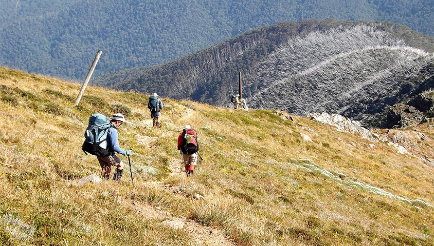
The wind was bitterly cold as we threw on our packs and set off, barely taking time to admire the sweeping vista of the mountains, with Feathertop and its prominent peak the stand-out attraction. Three and a half hours later we hunkered down beside the burbling waters of the Cobungra River for a well earned lunch before panting our way uphill via Cobungra Gap, passing to the west of the rocky outcrop of Basalt Temple until we arrived at Pole 267.
After a short break, we decided to add a bit of variety to our day and struck out on a north-easterly course across the open plains and an inquisitive mob of brumbies until we reached the Cope West Aqueduct Track, a maintenance track that led us around the back of Mount Jim and Mount Bundara towards Ryders Yards that loomed in sight as evening approached.
DAY 2: Ryders Yards to Ropers Hut
25km (8 hours, Moderate)
Ribbons of mists hung in the valleys and there was a bite in the air as we broke camp and hit the trail, only too aware that today would be a long grind. By the time we reached Cope Saddle Hut with its familiar crimson roof, the fog had lifted and the sun was shining brightly.
From the hut we ambled along the newly constructed track work that forms part of the rebranded ‘Falls to Hotham Alpine Crossing’. The walking was pleasant with extensive views across the plains and valleys with Mount Cope a dominant presence to our right. An hour after departing Ryders Yards we crossed the Bogong High Plains Road and arrived at the rather nifty Cope Hut.
From Cope Hut we followed the foot track that rejoined a vehicle track beside the Langford West Aqueduct and after passing the Rover Chalet we took a short detour to take a squiz at the recently refurbished Wallace’s Hut, the oldest surviving hut on the High Plains.
Back on the AAWT we continued walking on the vehicle track until we reached pole 625 where we took a shortcut to join Langford East Aqueduct and followed the track for about two kilometres to a tiny covered foot bridge. From there we strolled through pleasant snow gum forests, climbed the western slope of Marrums Point and lunched in the welcome shade of the snow gums.
The day had become quite warm and the next part of the journey was on the exposed section of the Big River Track with its expansive rolling plains and panoramic views west to Mount Buffalo and north to Mount Bogong. After passing turn offs to Edmondson and Johnston Huts we began the steady climb across the western shoulder of Mount Nelse (1882 metres) to the Warby Corner track junction. By now we were wishing for a bit of cloud cover to dampen the sun’s sapping heat. We continued heading north-east before swinging north and at long last began the descent into the snow gums, arriving at Ropers Hut in the late afternoon ready for a reviving cuppa and a lie down.
DAY 3: Ropers Hut to Cleve Cole Hut
11km (7 hours, Hard)
Although a shorter day distance-wise, we knew this one wouldn’t be quite as cruisy as the previous day – ahead of us was a steep 800-metre descent to the Big River crossing followed by a similar uphill slog to Maddisons Hut site and beyond.
When we left Ropers Hut, there wasn’t a breath of wind to disturb the leaves of the snow gums and after a two-hour descent on Duane Spur the faint tinkle of water over rocks indicated Big River was close. I recalled crossing the river some years earlier after days of heavy rain. Back then I had to cling grimly to the chain suspended across the river and hope like hell I wouldn’t be swept away by the raging waters. This time the river purled softly and the water was refreshingly cool on our bare feet as we waded across.
We refilled water bottles and sat for a bit by the river, putting off the inevitable thigh-burning, lung-busting climb out of the valley. An hour and a half later we sank to the ground at T Spur Knob (1650 metres) to catch our breath before a forty minute trek to an open grassy valley and the former Maddison Hut site. From here it was a virtual stroll up the valley to the picturesque Cleve Cole Hut.
DAY 4: Cleve Cole Hut to Mountain Creek Campground
13.5 km (6 hours, Moderate)
The final stage of our four day hike proved to be a pleasant day of “sightseeing”. After breaking camp beside Cleve Cole Hut we followed the track leading north west towards Mount Bogong. The morning was sunny and we were in high spirits as we reached Rocking Stone Saddle where we dropped our packs and searched to the east of the track until we found the odd rock formation consisting of an almost perfectly round stone encased within another stone.
Shortly afterwards we arrived at the junction of the Eskdale Spur Track where we veered left, dropped our packs at pole 1278 and made the 500-metre climb to the cairn on the summit of Mount Bogong (1986 metres) where we lazed in the sunshine and reflected on how fortunate we were to be able to sit atop Victoria’s highest peak on such a glorious day.
After collecting our packs we began the descent of the Staircase Spur, stopping every so often to marvel at the panorama before us. Despite having traversed this track many times it never fails to showcase the magnificence of the mountains with its steep gullies and craggy ridgelines. We passed the memorial to the three skiers who died here in 1943 when attempting to reach the summit hut in blizzard conditions and soon we back in the treeline and approaching Bivouac Hut and morning tea.
The rest of our descent was uneventful, just an endless downhill plod to the Mountain Creek Road and a long amble back to the campground. The first part of our journey was over and as we loaded our gear into the cars we were already discussing plans for our return in two month’s time.
DAY 5: Camp Creek Gap to Maddison Hut site
10km (6.5 hours, Moderate)
It was a foggy morning when we when we arrived at Camp Creek Gap for another four days of High Country glory. As with most hiking in the mountains we had another gut busting scramble uphill on the Eskdale Spur until we took a break an hour and a half later at the newly built Michell Hut.
After a short break we resumed the climb that took us out of the tree line and up and over the craggy peaks leading towards Mount Bogong which loomed out of the fast disappearing fog.
Lunch was taken on the grassy slopes near the track junction to Bogong proper and it was here that we were able to appreciate the solitude and quietness that draws us back to this part of the world over and over again. Replenished and refreshed we continued on along the ridgeline, past Cleve Cole Hut and down to the creek where we left our packs and followed the footpad to Howmans Falls, where the waters plummet spectacularly over 30 metres into the valley below.
After collecting our packs, a short stroll found us at the Maddisons Hut site where we set up camp as the sun slipped below Bogong and the air took on a decidedly icy chill.
DAY 6: Maddison Hut site to Mt Wills
16 km (8.5 hours, Moderate)
The morning was cold and foggy when we broke camp and climbed out of the valley onto the Long Spur to follow a well defined track that led us through a silent forest thick with mist. As we hurried along in an attempt to warm up we were assailed by showers of ice whenever the wind gusted through the trees.
Two hours of solid walking brought us to a confusing section of the track where the lead group was forced to backtrack after heading off down Malhauser Spur. After a bit of searching around we finally located a marker post indicating a faint track that we followed along the southern side of Long Spur that took us back onto the main track.
Shortly after we reached a logging track and descended to a saddle where another logging track met the Big River Road which we followed to the Big River saddle. We were now at the start of the track leading up to Mount Wills (1757 metres) a track that climbed steeply through an overgrowth of blackberries that pulled at our shirts and snagged on our socks. This last section neatly bookended the day’s start; with another massive uphill slog to Mount Wills.
The views from Mount Wills were nothing less than spectacular, with a clear view of the Long Spur ridge all the way back to Mount Bogong. As we perched on the massive granite rocks and the sunset bathed the sky with its soft golden light we marveled at how far we’d come and agreed the day’s toil had been well worth it.
DAY 7: Mt Wills to Gill Creek saddle
13.5km (7.5 hours, Hard)
After a restful night we woke to a clear morning and wasted no time hitting the trail which, although indistinct at times, led us through groves of snow gums to an old vehicle track and the rocky outcrop of Mount Wills South (1621 metres). The day was warming up as we descended the track and three hours after starting out we reached the Omeo Highway.
We decided to take a look at the old mining village of Sunnyside, so leaving our packs behind we strolled down the road and into the bush where all we saw was the crumbling remains of a brick wall and a piece of rusting machinery.
After lunch we left the highway and heading north followed the AAWT markers along the broad timbered Gill Spur Track until it swung to the south east and descended sharply towards Gill Creek where we planned to camp the night. A few hundred metres before Gill Creek we encountered a rather large Alpine Copperhead who took some convincing to clear off and when we arrived at the creek, situated in a deep, narrow and thickly vegetated valley with limited tent space, we decided to continue on; besides, there was the uncertainty of exactly where ‘Joe Blake’ might be.
After loading up with water we struggled up a steep section of track for about 1.5kms until we reached a slight saddle where we could pitch our tents in a line along the track. It was obvious by the remains of a campfire that others had done the same before us.
DAY 8: Gill Creek saddle to Taylors Crossing
13km (5 hours, Moderate)
Our last day started just like the first with a steep uphill section and as the forest opened out we followed the crest of a well defined spur through open woollybutt forest to the Wombat Divide Track. A steep and steady climb kept talk to a minimum and after a breather we followed the Eight Mile Loop Track for about five kms to Toms Link Track which eventually linked up with Kellys Track and then Four Mile Creek Track. It had become quite hot by now and the thought of reaching the Mitta Mitta River spurred us on. After another 3kms we turned off the vehicle track and onto a foot track through light forest to finally emerge at Taylors Crossing where a substantial suspension bridge spans the river and leads to a serene and expansive picnic ground. Our two-part, eight day trek was over, now it was time to relax and cool off in the deliciously cold river.
To see the printed Track Notes with full colour map, see Wild issue 159. Subscribe today to receive your copy.