

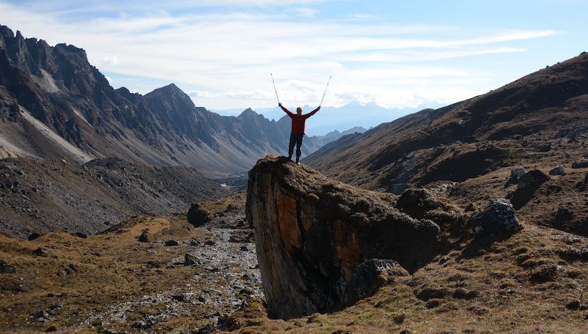

The author enjoying 360-degree views of the HImalayas. Photo: Mike Cocker.
Our guide, Namgay, had promised us a long day and sure enough by mid-afternoon I’m struggling. This is a result of the combination of altitude, a difficult trail and having sweated so much on the steep climb up. We had stopped for a long lunch break at the only flat spot, but since then the pace has been unrelenting. There are many small descents built into the overall ascent and the footing is eroded and mostly very rocky, requiring concentration in foot placement.
The climb up the north side of the valley has been precipitous and scenic. As we’ve slowly got higher the vegetation has changed from the heavy forest canopy in the lower gorge, through to smaller trees and then sparser vegetation, until now at 4,000 metres we’ve reached the tree line. In contrast to the ravine below, we emerge into a flat and broad valley. Crossing a bridge over the torrent we can see a herder’s hut in the distance that will be our home for the night.
I’m on the 12th day of the Snowman Trek – about halfway through. It is claimed there have been more summiters of Everest than people who have finished this trek and it is reputed to be one of the hardest. Only half of those who start successfully complete. But is that advertising hype or a fair description? In numbers, we are talking about 350 kilometres over 25 days, ascending to 11 passes over 4,500 metres above sea level and five of these are over 5,000 metres.
Yaks With Attitude
It’s the first day with yaks carrying our gear. At altitude they go better than ponies and are tougher in snowy conditions. Trouble is that a couple of days ago this lot were grazing free on the mountainside and now they are reluctant beasts of burden carrying loads of camping gear and personal effects along narrow trails. They do so at their own pace and, weighing in at up to 500 kilograms each, are not to be trifled with when the track is exposed to big drops. It is my first trek not carrying my own gear – but I think I could get used to this quickly.
Bhutan is a mountainous country sandwiched between the world’s two most populous nations – India and China (Tibet). Famously isolated in the past due in particular to the difficulty of travel. Even today there are few roads, a single tiny airport at Paro and a handful of international flights. The population is less than a million. Where we are trekking the boundary between Bhutan and Tibet is disputed and Google Earth shows two options. Things are testy with China but that does not stop goods being traded in both directions by pack animals over the high passes. Via these historic routes came Tibetan invasions, but today the shared Buddhist heritage and culture brings mutual sympathy. Bhutan’s foreign policy is aligned with India.

The Snowman Trek lives up to its name. Photo: Mike Cocker.
In September and October there is a trekking window of about six weeks between the end of the monsoon and the onset of winter which heralds the closure of the passes. As it turns out, in 2015 we nailed it. Every high pass is clear and we are treated to huge, clear views. It gets very cold and there is some snow, but the rain jackets hardly ever come out.
The yaks arrive just after darkness falls and despite a black, moonless evening the tents are erected quickly and belongings reunited. Three hot drinks followed by a meal make a big difference and there’s a general sense of wellbeing around the table – the only night on the trek we were not in the dining tent. In bed shortly after 8pm – our daily walking starts at 7.30am – and sleep well on a good flat campsite.
In the morning we have a sharp climb of about 300 metres that takes us into a hanging valley leading to Tsome La pass at 4,900 metres.
Rosie, one of two vets in the group, gets seriously cold hands and we do not warm up until, cresting the top of our first climb, we reach the warming rays of the sun. The route up to the pass through scree and moraine is not hard and we get there by late morning.
Rosie and her uni friend, Kate, have treated a footsore pony as well as a herder whose head was gashed after being kicked by one of the more bad-tempered animals. Rosie is an inspiration – an experienced ski mountaineer, she has had not one but two hip replacements and is a strong climber in the group.

The arduous route followed on the Snowman Trek.
The Way to The Remote Lunana Region
These three days are at the crux of the trek, with high passes leading to the remote Lunana region. For Namgay and the trekking crew of seven it is also the key challenge. Once over we are committed – the way out is onwards for another ten days. There are no roads, no airstrips and the country of Bhutan owns no helicopters ¬– the only possible emergency evac option is to call in the Indian army.
The route now crosses a high, barren plateau. We stop on a spur below the track for another amazing lunch stop with great views and then on a long but steady contouring climb to the night’s camp at Narethang. We are below the glaciated west face of Gangla Karchung, a 6,400-metre peak to be skirted to the north. The elderly yak herder indicates that when he was young the glacier reached way down the valley. Now there is only an empty gorge bounded by huge moraine walls. A small avalanche comes off above us with snow streaming down a gully.
One of the features of the trek is digital detox as we go beyond the reach of modern technology. These things will arrive in the region and no doubt will change lives for the better, but for us it is a precious escape.
After dinner each night, one of us takes the floor to tell a tale on any topic we like and much fun is had. Namgay is the superstar, on his tenth Snowman Trek in as many years he knows the trial intimately. An erudite man, he enlightens and entertains us constantly with stories of Bhutan and Buddhism and how the people live.
The sloping campsite means a night of sliding down the Therm-a-Rest. I try a system of cords to arrest the sleeping bag at the top of the tent with me in it but it’s only partially successful. There must be a design innovation opportunity here. We have read that if you roll a rock down the south side of the Himalaya then where it stops is where Bhutan ends. Sounds plausible, as flat ground on the trek is at a premium and, as campers, we have come to appreciate level places.
Later it gets damn cold and, due to the high camp, I sleep poorly. A chart on my Bhutan map says we have 53 per cent of the oxygen normally available at sea level. As a low-living Aussie I’m glad that I invested in new, warm gear – both down jacket and sleeping bag are 800 loft and the bag rated to -11. Combined with a merino base layer of clothing it’s adequate. I’ve brought four hats for different sun intensity and temperatures given that a quarter of all heat loss occurs via the head. Tonight is a balaclava night…
…The adventure continues in Wild 155. Subscribe today for the full story and much more, including camp recipes, track notes and gear reviews.