

By Ciaran Ryan
It’s about four in the afternoon.
With little more than a paltry serving of bananas and oats lining our cavernous stomachs, the five of us bundle out of the car and stretch our backs, craning our necks skywards as we spy the snow-capped peak of Mount Cook in the distance. Then it hits us: we are all utterly exhausted and have roughly four hours –or 2,200 steps up and 2,200 steps down – still to go. We utter not a word.
The four with me are Jarred, Dan, Tim and Beef: old friends from high school whom I’m road tripping New Zealand’s South Island with. As we stand and look up at the Southern Alps thawing under the violent sun, that evanescence of tiredness passes. Instead, it gives way to an excited current that electrifies the air. We take our first steps through the grassy gully leading to the base of the Sealy Tarns Track.
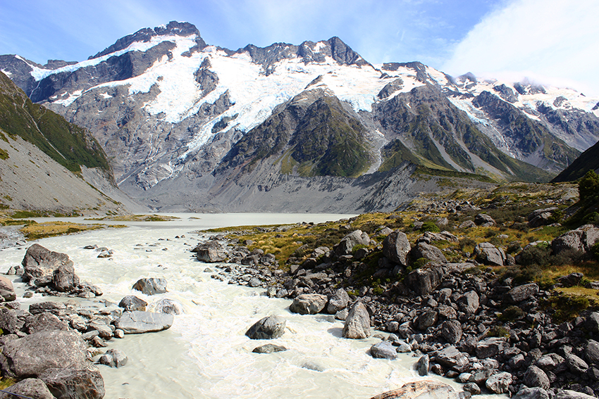
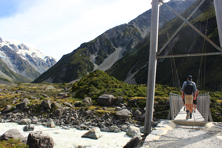
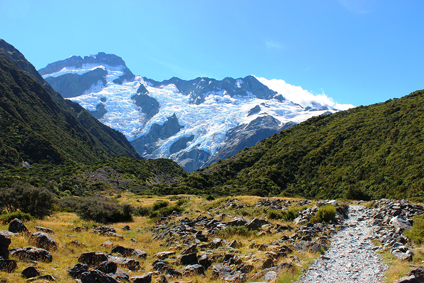
Earlier that morning, our first in the Aoraki/Mount Cook national park, we weaved five hours through the Hooker Valley: a tortuous path broken occasionally by swing bridges, craggy paths, glacial streams, and tussock grasslands – each nestled uncomfortably between Mt. Sefton and Mt. Cook. The walk should have taken only three or four hours. However, because of the perfect weather window, we chose to veer off course every opportunity we got, hopping across glacial streams as the water undertow swarmed each boulder like molten silver rushing forth from the Hooker Lake. This is, of course, the best way to sneak a better glimpse of the Mueller Glacier—not to mention the wild cherries, lupin, and mountain buttercup that decorate the landscape.
Compared with the tourist hotspots of Queenstown and Franz Josef, the burnished veldt surrounding the village of Mount Cook has an untouched and barren quality to it. Peaceful probably describes it best. As for the village? A ghost-town—to use a well-weathered cliché. To illustrate this point, our hostel acts as the town’s supermarket where an array of canned goods gets replenished once a month – well before the previous batch ever sells. The isolation, though, is far more pronounced in the open. Passing only an occasional group of hikers, European backpackers, or the lone bohemian straggler, the seclusion has a soothing effect as you begin to lose yourself farther from the village: a feeling that becomes almost routine the more you spend time in the South Island.
Eventually, we arrived at Hooker Lake where a curious sight reeled in our attention. Despite the searing heat, despite the cloudless summer sky, and despite how late into the afternoon it was, a turquoise ice-chunk drifted slowly towards the rush of white water at the mouth of the Hooker River. We scarpered to the east edge of the lake, pulled out our cameras and took a few snaps before sidling up to the torrent of water at the river mouth. Though tempted to take a dip, we thought better of it. None of us particularly wanted to test the effects of concussion on our ability to float. Instead, we perched ourselves on a large rock and sat as the water rushed past us. I particularly enjoyed watching the stones overturn in the swirling current. However, as is always the case, though we wished to linger, our hunger grew more savage, and it was time to hasten back towards our hostel.
We scurried into the kitchen, shovelled some bananas and oats into our mouths and eagerly rummaged through our map. With a few hours of daylight left, where would we venture next?
The Sealy Tarns Track.
Which is where I find myself now.
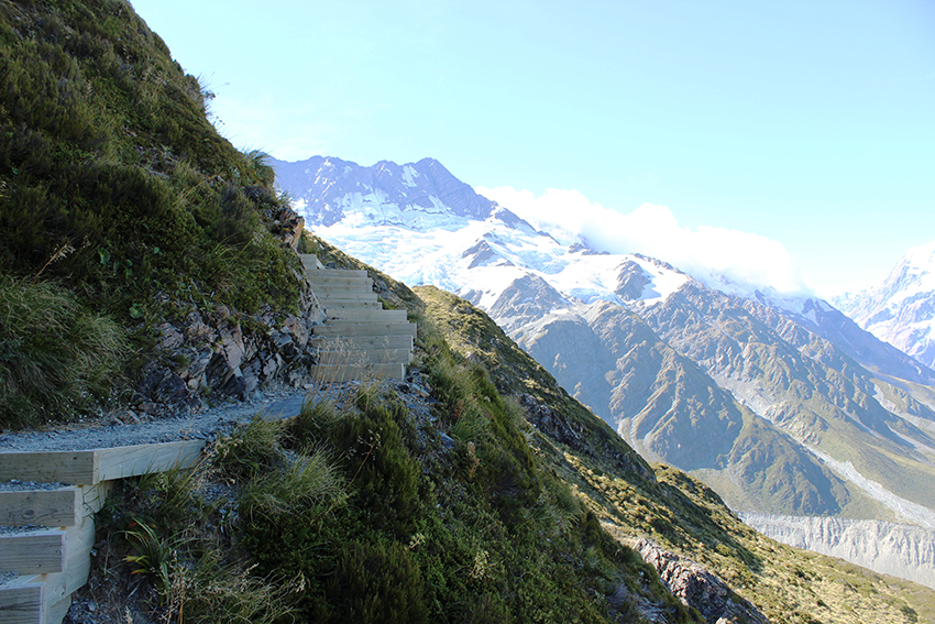
Confident we should be up there in an hour-and-a-half, considering the ease of the 1,000 steps (Kokoda Memorial Walk) at Mount Dandenong we’ve done countless times East of Melbourne, we take our first steps up and think nothing of it. At first, our bravado is corroborated. The track rises gently in a winding maze of dirt and gravel which we navigate with ease. Only a few groupings of five timber steps spaced twenty metres apart along the gentle hairpins cause us slight grief.
However, minutes later the timber steps wedged into the earth become larger railway sleepers that rise more sharply and frequently. Soon enough, the flat land between the sets of steps quickly disappears. The sets become one continuous rise. Respite becomes a myth. The jocular badinage between the group falls silent; we can ill afford to expend the words between our increasingly laborious breaths. Our calves, our thighs, our knees—all seized by a heavy burn. But we lumber upwards: thumping our boots with each step and sucking in deep lungfuls of air, wicking away the beads of sweat before they have time to form dirty, brackish estuaries in the lines of our scrunched faces.
A patch of shade creeps out from underneath a narrow escarpment. We rush towards it and huddle underneath the thickets of ti kouka, a spiky shrub known as the cabbage tree (whoever named it no doubt possessed a steel tongue). We pause to ease our wheezing.
“Lovely day for it, isn’t it, boys?” says an American woman as she hurries down past us with a jovial zeal.
“Sure is,” puffs Dan.
“Are we close to the top?” I ask, pleading for her to say ‘yes’. “Maybe halfway?”
“Halfway? You’d be lucky to be even a fifth of the way there. You’ve still got a long way to go yet, boys.”
We stand and chat with the woman a little while longer. Like many American trampers, the conversation is largely one way and we struggle to slip in a word as she compares the local scenery to her native state of Ohio. We listen with a slight reproach as she advocates the grandeur of her home state in a way that almost dismisses our current purlieu—ourselves left to wonder how anything could dare challenge the pristine vista before us. The woman then slips away below.
With a renewed enthusiasm, or perhaps hubris brought on by lightheadedness, we march upwards again. However, because the track information in the pamphlet says the walk takes four hours round, and because we believe we are scarcely twenty per cent of the way there, we’re convinced we’re terribly behind schedule and push on, taking very few breaks. My pulse is beating in my ears.
And it turns out I’m not alone.
“Just a minute here, alright?” says Dan, the rest of us silently thankful of the short stop as we watch Dan almost keel over.
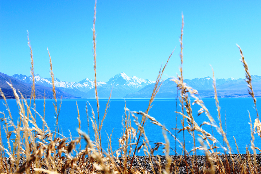
I remove my sunglasses and run my hand along my forehead and then down past my neck. My cheeks are florid in the reflection. My flesh warm at the touch. I look up: only hours before, Lake Tekapo stretched as far as my eyes could see; now, I can squeeze that very body of water squeezes between my fingertips.
But as I marvel at the pitted earth four-hundred-metres below, the already notorious sun truly beings to announce its savagery. Sweat stings my eyes. I unbutton my shirt and waft the air against my flesh. Why did I conceive it wise to hike in a Hawaiian shirt today? Though, it doesn’t really bother me. Nor do my throbbing calves. In fact, nothing does. Strangely, I feel insurmountable. And it is with this resolve that we’re off again, pacing ourselves at the speed of our slowest member: a courtesy that ought to be extended more often than it seldom is.
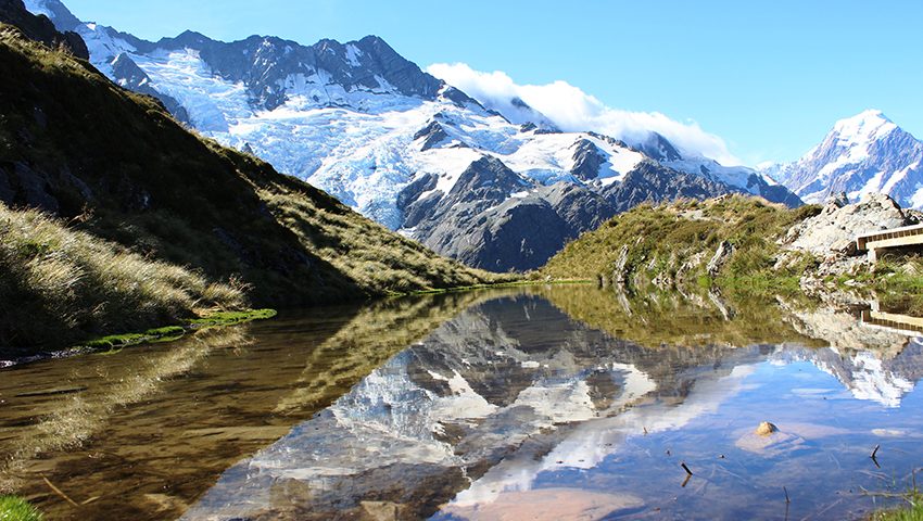
Before long, we arrive at Sealy Tarns. The surrounding Alps reflect off the naturally formed tarn. Whenever the wind halts, for but a moment the watery sheen is a mirror to the world above.
Describing it that way, however, does little justice. The sight before me is far simpler in its complexity: immense. A raw purity shines opposite us where charcoal coloured rocks tumble for miles underneath the serrated ice ridge leading to Mount Cook almost four kilometres high in the sky. It is as if years ago Papatuanuku, the Maori Earth Mother, had in a rage thrust her fist into the molten crust and stormed off – an imposing mound of rock and ice the only evidence of her fury.
Tim pulls out his Garmin GPS and shows us our current elevation. At that moment we stand 1,336 metres above sea level. He presses one of the buttons and we look at the screen: a line measuring elevation relative to distance juts upwards at a slight angle from when we walked along the Kea Point Trail, only to surge near vertically from the time we reached the base of the track to where we stand now. Put simply, we have zigzagged less than three kilometres and risen 547 metres from the valley below.
“That lady must have thought we were going to Mueller Hut,” says Tim when we remember she told us earlier that we were scarcely twenty percent of the way there.
“So we could have taken a few extra stops then?” says Beef.
We each nod languidly.
Mueller hut is another 450 metres higher, though with a sharper rise and more rugged trail than the tarn—it would effectively be like repeating the arduous two-hour trek we just completed. Only more difficult. Not only that, but climbing down would be fraught with uncertainty due to the unstable and steep footing.
Many of those we passed along the way were heading there having already paid to stay overnight. Those who only wanted to march up and down had been wise enough to do so earlier in the day. Even this late in summer, the ridge is treated with respect due to how abruptly the weather can blanket the entire valley in sudden cold.
A 28 bed alpine hut 1,800 metres above sea level along the Mueller Ridge, Mueller Hut is likely the only place for amateur climbers (a term used cautiously) to perchance lay witness to footfalls of snow this late in summer. The panoramic view provides the best vantage point of the surrounding glaciers, vertical rock faces, and ice cliffs. And prodigious these cliff-faces are: large seracs the size of trucks frequently snap off the precipitous ice and rocket down into the valley opposite. In fact, after April, the walk is a considerable avalanche hazard, and, because of the need of crampons and an ice axe, it is strenuously recommended that only experienced climbers, with keen knowledge of the area, attempt it. Such climbers typically use the hut as a base camp for climbing Mount Sealy, 2,627 metres above sea level, south of Mueller Hut.
In summer, however, day trekkers can instead venture thirty minutes south from Mueller Hut and ascend Mount Ollivier— a glorified pile of loose rocks famous for being the first peak summited by Sir Edmund Hillary in the Winter of 1939.
“Do we want to keep going?” asks Tim.
We deliberate for a few minutes, and though we envy the shifting bodies above us along the track, having expended much of our energy earlier in the Hooker Valley, knowing we have a five hour drive at dawn, and with the sun now beginning to dim behind us – though we know we’ll regret not climbing upwards as soon as we arrive back at our hostel – we decide it best to climb no higher and instead loiter at the tarn a little while longer. A group of Canadians on their way up to Mueller Hut snap a picture of the four us. And as I go through my camera and look at the pictures I’ve taken, I let the lens fall back down around my neck and absorb one last look of the view before heading back down; a sour taste forming in my mouth as we leave the hidden oasis tucked amongst the clouds.
It’s easy to see now why the climb is affectionately known as the Stairway to Heaven.
On our way down, near the base of the steps, we pass a Japanese man in his late thirties with his two sons—both no older than six or seven. “Are we almost there?” says one of the boys.
The four of us chuckle, remembering that we had asked the exact same question only hours before. “Maybe a third of the way there,” I say.
“Oh, no! I’m already tired,” says the younger of the two boys.
“No, you’re not. Keep going,” says his brother.
“Trust me, it’s worth it when you get up to the tarn.”
“Tarn? No, we go Mueller Hut,” says the boys’ father.
The four of us stare at him at disbelief: it’s approaching 7pm. The sun has long lost its warmth. At best, the return trip from Mueller Hut would take five hours, assuming the climber was of an above average fitness level with some degree of tramping experience. Somehow, I doubt the sweaty youngsters could do it in less than eight—or well after midnight.
“Nah, you’re no way near Mueller Hut. Fifteen, maybe twenty percent at most. Are you planning on staying up there overnight?” I feel foolish as soon as I ask, as between the three of them they have two 600ml bottles of water, both half-drank already, and none of them are carrying a backpack.
“No stay. Just up and down,” says the father.
The four of us try and gently persuade him to venture up to the tarn and then return, explaining that they will likely be out until well after midnight, when the overnight cold has firmly draped the valley. But his will upwards is incorrigible. So we wish him and his sons the best and continue downwards. Though the National Park Service Ranger maintains Mueller Hut every so often, considering all of those we passed on their way up to Mueller Hut intended to stay the night, we doubt much sustenance, let alone shelter, will be available when the three tourists arrive after dark. One only hopes common sense prevails well before then.
Fifteen minutes later we arrive at the base of the track and find ourselves again navigating the prairie, when suddenly a sharp creak sounds behind us followed by a distant rumble that booms like rolling thunder.
“Did you just see that?” says Beef, pointing at a large shoulder of ice.
“What?”
“A massive chunk of ice just cracked off over there and fell right down.” We stare at where Beef points and look at the ridge leading to Mount Cook. Only an hour ago we were level with the ice opposite. We wait and hope to witness a reprisal. But nothing comes of it. The rest of us have only the awe of the mountain’s sound to remind us of its power, of its mythic awe.
If only we’d stayed up there a little while longer.
Before long, we’re back in the car park. We toss our bags inside the boot and bundle into the car and wind the windows down. And as we drive off, joking mildly about the father and his two sons, wondering if we’ll be needed to form an impromptu search party in a few hours, whilst also ruing that the photos we took don’t give the expanse of the national park nor our elevation justice, I can’t help but realise why it is so often that some people find themselves victim to a relatively innocuous wilderness. Especially one which draws a snigger from locals when somebody runs into trouble. It seems that a combination of wilful ignorance and underestimation of the locale can turn even the simplest walk into a struggle if careless. Because, though the Sealy Tarns track was exhaustive, at no point—unless one had an underlying heart condition—did I think it a particularly dangerous one. Rather, it seems that in their refusal to treat an unknown terrain with a modicum of respect, some people make things so.
I guess one can never be too prepared.
But just as I walk in through the hostel door, as soon as I kick my shoes off and collapse deeply into the worn leather couch, my attention is drawn elsewhere, and I’m immediately hit by a thought I knew was inevitable.
I really, really wish I had ventured up to Mueller Hut.![]()